
Geotechnical Drilling & Subsurface Exploration Across Texas
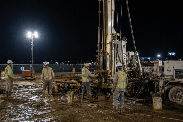
Quartet Engineers coordinates geotechnical and environmental drilling to obtain site-specific subsurface data for design, due diligence and investigation. Boring locations and depths are planned around the project decision, with field logs, samples, laboratory testing and reporting connected through one controlled workflow
What we offer
Services
Soil boring services.
Hollow stem auger drilling.
Direct-push exploration where appropriate.
Sampling and groundwater observations.
Environmental drilling and sampling support.
Monitoring well installation support.
Borehole abandonment and documentation per scope.
Field logging, sample custody and laboratory coordination
What determines boring depth?
Proposed construction, anticipated foundation loads, site history, soil profile and the engineering or environmental questions determine the exploration depth and sampling program.
What should an owner provide?
Provide the site plan, proposed improvements, access constraints, known utilities,project schedule and prior reports.
Does drilling automatically include a report?
No. The proposal should state whether drilling is part of a geotechnical report, environmental investigation or stand-alone field scope.
.png&w=3840&q=75)
FAQ
Geotechnical Drilling & Subsurface Exploration — Frequently Asked Questions
What Texas developers, GCs, and municipal engineers ask us about drill rigs, soil borings, site access, and what actually happens between notice to proceed and samples arriving at the lab.
Lightning stops work, full stop — a drill mast is the tallest steel object on most sites. Rain itself rarely stops the drilling; it stops the access. Gulf Coast clay sites that a truck rig crossed on Monday can be impassable Wednesday, which is when track rigs and mats earn their keep. Wet-season fieldwork mostly means planning: rig selection for the forecast, sequencing borings from firm ground outward, and protecting samples from moisture gain between rig and lab. Hurricane season occasionally costs a week outright — build slack into fall schedules. Drought is the opposite problem: easy access, but the crew is sampling clay at its driest, which the engineer must account for when estimating seasonal movement.
Routine Houston-area geotechnical borings run 15 to 40 feet; mid-rise, industrial, and settlement-sensitive projects commonly go 50 to 100 feet, and specialized programs deeper. The rig is rarely the limit — the engineering program is. Termination depth is set before drilling: deep enough to pass through the seasonal moisture-change zone in expansive clay, penetrate any weak or compressible layers, and reach below the foundation's zone of influence — including the bearing stratum for drilled piers. Crews extend borings in the field when they hit unexpectedly soft material at planned depth, which is exactly the surprise you want caught now. Practical exceptions exist — refusal on dense material or unexpected obstructions — and are noted on the log with the engineer deciding next steps.
Yes, with planning. Industrial and marine facilities add badging, safety orientations, facility work permits, air monitoring, and often air-knifing or hand-augering before the rig touches soil. Quartet Engineers crews work in active refinery tank farms, Port Houston-area facilities, and municipal rights-of-way across Harris County, so this coordination is routine rather than exceptional. Roadway work adds traffic control to Texas MUTCD standards, lane-closure permits from the city, county, or TxDOT, and often night or weekend windows. All of it is schedulable — the failure mode is discovering the requirements after mobilization. For these sites, the pre-drilling paperwork can take longer than the drilling. Start facility approvals and permits the day the proposal is signed.
Boreholes are backfilled when drilling and groundwater observations are complete — with soil cuttings on routine work, or with bentonite or cement-bentonite grout where the project, jurisdiction, or groundwater conditions require a sealed hole. Pavement cores are patched with concrete or cold-mix. Sealed backfill matters where a boring penetrates a water-bearing zone or connects strata that should stay separated; some public and environmental specifications require grouting outright. If a piezometer was installed for monitoring, it stays until the observation program ends and is then plugged. Practical note for site owners: mark and remember boring locations. A grouted borehole is not a defect, but your earthwork contractor will appreciate knowing where they are.
The crew records water levels during drilling and again after a delay — often at completion and 24 hours later where the borehole can safely stand open. Two readings exist because clay is slow: water seeps into an open borehole gradually, so the during-drilling level often understates the true static level. Reports distinguish perched water — trapped in a sand seam over clay — from the actual groundwater table, which behave differently for construction. On the Texas Gulf Coast both swing seasonally, so a dry August reading is not a promise about your wet-season excavation. Where groundwater is critical — deep excavations, below-grade structures, dewatering design — a piezometer installed in the borehole gives long-term readings a one-day observation cannot.
The drilling contractor calls Texas 811 before drilling, and public utility operators mark their lines — that part is routine and included. The trap is that 811 only covers public utilities up to the meter or property line. Private lines — site electrical, irrigation, gas to outbuildings, process piping on industrial sites — are not marked by anyone unless someone hires a private utility locator. On developed or industrial sites, budget for a private locate or provide as-builts, and expect the crew to hand-auger or air-knife the first few feet at higher-risk locations. Striking an unmarked private line is the classic avoidable drilling incident: the locate costs a fraction of one repair, never mind a hit gas line.
In Gulf Coast clays, crews push thin-walled Shelby tubes to recover relatively undisturbed samples — these feed the swell, strength, and consolidation tests that Houston foundation design depends on. In sands and harder layers, a split-spoon sampler is driven with a standard 140-pound hammer, producing the SPT N-value, a field index of density and strength. The distinction matters more than it looks. Swell and strength testing on disturbed samples produces garbage numbers, and expansive-clay design built on garbage numbers is how slabs get under-designed. Sampling method and interval are engineering decisions in the boring program, not crew preferences. Boring logs record which sampler was used at every depth — it is worth glancing at when you review the report.
A truck-mounted rig is the default: fastest mobilization and best production on paved or firm open sites. A track-mounted rig takes over when the ground is soft, wet, or unpaved — most of the Gulf Coast for much of the year. Limited-access rigs handle what neither can: inside buildings, under canopies, or in tight courtyards, working in roughly 6–7 feet of headroom. The choice is driven by ground condition, overhead clearance, and boring depth — limited-access rigs trade capability for reach, so very deep borings may dictate the location of the rig rather than the other way around.
Yes — this is a rig-selection problem, not a stop condition. Track-mounted and all-terrain rigs handle soft ground, wooded tracts, pipelines rights-of-way, and levees; timber or composite mats bridge the genuinely wet spots; and portable or tripod equipment reaches locations nothing self-propelled can. Houston-area examples where this matters constantly: flood-control channel slopes, undeveloped Fort Bend and Waller County tracts after rain, and utility corridors. Slope work may add anchoring or benching; heavily wooded sites may need a cleared path, which belongs in the right-of-entry conversation early. The honest trade-off is production rate — limited-access setups drill fewer feet per day — so flag access conditions at proposal stage rather than on mobilization morning.
The crew confirms utility clearance, moves the rig to each staked location, and advances the borings while a logger records soil layers, sampling, and groundwater. A truck-mounted rig typically completes two to four 20–40 foot borings per day in Houston-area clays; samples are sealed on site and delivered to the laboratory. Have ready: legal and physical access (gate codes, escort, right-of-entry), boring locations cleared of obstacles, and any private utility information you hold. On occupied sites, tell tenants — a drill rig at 7 a.m. generates phone calls. Expect some site disturbance: rig tracks, cuttings, and patched boring locations. A good crew leaves the site close to how it found it, but this is drilling, not landscaping.
Ready to start?
Your project success starts here.
Tell us about your site and project goals — our geotechnical team will scope an investigation program sized exactly to what your project needs.